THE HISTORY WITHIN A WALL
by GEOFF PARDON
Take a look at any traditional Norfolk wall or building and although at a glance it’s just stone, brick and mortar it contains a wealth of local history. Here in Trimingham we have many old cottages, walls and buildings in the traditional Norfolk style that date from the 18th and 19th centuries, or even earlier. These structures have three main components, traditional red brick, flint stones and all constructed using a lime mortar.

THE BRICKS
The principal method for making bricks remains basically the same today as in Roman times, a mixture of clays, sand and water, moulded, then dried and finally fired in a kiln. Up until the end of the 19th century the bricks used in any building would have all been hand made locally; with no canals, railway or suitable road links in the area transportation any distance was a problem. It was, however, possible to transport the bricks a few miles with horses or mules pulling a tumbril. Nearby Mundesley had two established brickworks in the 19th century and the majority of the bricks for building in the area came from these until the arrival of the railway at the turn of the 20th century.
The Mundesley brickworks were established to supply the building of the growing number of grand houses in the area, and Willaments Brickyard was on the east cliff and the Mundesley Brick & Tile Company had a site on the west cliff; they were both sited close to the cliff top. The raw materials were at hand directly from the beach and cliff face, and both companies had their own beach access. Nothing remains of Willaments on the east cliff, all lost to erosion. What remains of the west cliff site is now Kiln Cliff caravan park, and the bottle kiln there is the smaller one of two that were on the site. This became the manager’s office and one of the long drying sheds became a general stores.
The colour of bricks is directly related to the raw materials used to make them and the geology of the area. Here, the glacial sands and clays from the Pleistocene age of 1.5 million years ago produced the familiar “Norfolk Reds”. These bricks were quite soft and “weathered” easily. A much harder brick could be produced by adding a chalk clay (marl) to the mix and these bricks had a yellow or pink colour and were often used as floor bricks (pamments). The clay mixing process used a horse-powered “pug” mill, a process by which the clay, sand and chalk were mixed together with heavy stone wheels pulled around in a large wooden barrel by the horse. After mixing, the wet clay was hand-thrown in wooden moulds, then air-dried, before being fired in the kiln. The drying sheds were long, open-sided and with a tiled roof. The air-drying could take around 3 to 6 weeks, but this was all dependant on the weather.
The next stage was to fire the bricks in a kiln and they had to reach a bright red heat (950 to 1150c). Early “clamp” kilns were partially buried and connected to a chimney to create a draught for the firing. The firing chamber was at one end of the “clamp” with channels under where the bricks were skilfully stacked to create air flow, and the whole stack of several thousand bricks was covered over and sealed with turf. Once the firing chamber had been lit it had to be continuously attended to maintain a constant heat. The firing process took several days and required large amounts of fuel. Early kilns used wood but coal became more widely used as it produced greater heat. Coal for the Mundesley brick yards was landed on the beach. Sailing coasters brought the coal from the northern coal mines, beaching at high tide, then at low tide carrying it to a coal yard near to The Dell by horse and cart. The old coal yard area is now housing beside the track to the beach at the Dell. The arrival of the railway in 1898 saw the end of the coal ship trade and the railway companies established coal depots at many local stations.
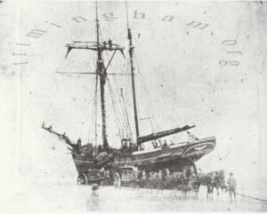
The IRIS, a coal ship discharging its cargo on Mundesley beach 1875
In 1769 parliament legislates for a standard size for clay bricks and a size of 8.5 ins x 4ins x 2.5 ins was given for general building use. In 1785 a brick tax was introduced at 2s 6d (12.5p) per thousand for standard bricks, which was to pay for the war in the American colonies at the time. But this proved a difficult tax to collect as many local brickyards turned to producing “non-standard bricks” to avoid the tax and 9.5 ins x 4.5 ins x 2.5 ins became a common size. Parliament moved to tax bricks by volume when moulded, but this proved even more difficult to enforce and in 1850 the “brick tax” was repealed. The standard brick size changed again in 1965 and a size of 8.52 ins x 4.2 ins x 2.52 ins was established. Finally metrication saw the standard size as 215 mm x 102mm x 65mm, and in 1969 this became British standard BS 3921.
It is possible to date an old property by the size of its bricks, and anything built locally before 1850 is likely to have the non-standard bricks.
THE STONES
Pre 20th century flint stones found in Norfolk building work were a locally sourced material and vast quantities could be found lying on the open beaches along much of our coastline. Most coastal villages all had “cart gaps” and this enabled access to gather stones and other materials from the beach. The cart gaps were allowed by the local land-owners but a charge was made for every load taken from the beach. In the latter part of the 19th century the sum of 6d (2.5p) per bushel was charged for sand, shingle and stones. A bushel is a now obsolete unit of measure equal to 8 gallons in volume.
Flints are a product of the local geology, formed in the Cretaceous period between 160 and 70 million years ago; they are a product of organic life within the bed of the ancient sea which once covered much of this area. The organic matter combined under great pressure with silica from the chalk deposits formed into hard nuggets called chert. These are the familiar “flints”, found on the open beach after erosion of the cliffs and sea-bed, and their familiar rounded and gray colour comes from being tumbled by the wave action.
A quick look at any wall will confirm that the stones all have a regular size. This was because they were all hand-picked when gathered on the beach and this was one of the tasks undertaken by local fishermen during times when it was not possible to venture to sea. The stone-gathering continued until the start of the 20th century when it was feared the removal of beach material increased the dangers of erosion and in 1912 the practice was stopped and outlawed, except for one exempted group, the local fishermen, who used stones and sand-filled sacks as ballast in their crab boats whilst under sail. Following the ban, builders turned to using quarried stones. However, these proved expensive and lacked the smooth and regular shape required. The quarried flints also had jagged edges, so many buildings from around this time used “knapped” flints which gave the flints a shiny black colour.
THE MORTAR
Once again, this was a locally sourced material and a product of the local geology. First introduced by the Romans, the process of making lime involved burning limestone to a high temperature, which created a chemical change causing the material to dry out and break down into a fine powder which, when mixed with sand and water, caused the mortar to set and bond. Most of the local area has a limestone bed-rock and here at Trimingham there is a very pure chalk limestone seam exposed in the cliffs and also at beach level. An 1886 OS map shows a chalk pit at the cliff face on the Low Grounds to the west of the village. Limestone is also referred to as marl and this gave the name to Marl Point at the very eastern end of Trimingham beach.
By the late 17th century there had developed many uses for lime: large amounts in agriculture for soil improvement, and in building for mortar and plastering. It was also used as a lime-wash for whitening interiors and water-proofing walls, as well as for bleaching paper and in the preparation of leather. Early kilns were always established near to the raw materials and here at Trimingham by the mid 19th century there were two to the east of Taylor`s Lane, marked on the OS map of 1886. By the end of the century these had moved to the Lower Street area near to Cliff Farm. Both areas have now been lost to cliff erosion.
The kiln type used here at Trimingham were periodic flare kilns, and these are the same in principle as the Romans had used, and were built into a bank or sloping ground near to the raw material. A periodic kiln was loaded, fired, allowed to cool and then emptied by hand. The limestone and chalk was dug by hand from the beach and cliff-face using picks and shovels, then brought up the cliff track to the kilns by horse and cart. The kiln was fired with coppiced wood and burnt continuously for up to 36hrs, before being allowed to cool and then emptied before being refilled. A periodic kiln produced a clean white lime which was best for lime-wash and plastering as the charge did not come in contact with the fire. For agricultural purposes marl was used, which was limestone with a partial clay content and it had a yellow/cream colour.
At the peak of production the lime caused many complaints within the village as the transportation along the streets and lanes caused it to be spread into people’s houses. In the latter part of the 19th century the council moved to ban the transportation of agricultural lime during the summer months between the Crown & Anchor and the Rectory at Hall Lane.
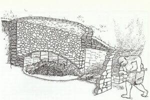
A sketch of a periodic kiln. A wooden structure supports the lime stone, and the initial firing sets the dome shape, which then supports the charge. The wood supports were burnt away during the firing process.
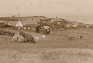 The Low Street area in around 1920. The lime kilns are the grassy mounds across the track in front of the cottage, and there is a pile of lime beside them. The track continues to the right and on to the cliff access. The cottage was called Lime Kiln cottage and in the census of 1911 a Mr Thomas Marshall lived there and was listed as being a lime burner. There was also a Mr John Bullimore living at Cliff cottages, also a lime burner. The larger wooden building is Windy Ridge and the only property which remains today.
 A team of horses taking materials from Mundesley beach, around 1900
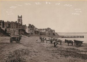 Cromer beach mid 19th century. The gathering of stones from the beach: a print from an album of engravings of 19th century Cromer. Note the original landing jetty in the background.
 On Trimingham beach 1905: an old postcard showing materials being taken from the beach to the cliff track.
The sand used for mixing in the mortar was also taken directly from the beach and carried up the cliff track. The coppiced wood for firing the kilns came from plantations to the west of the village and in the 18th and 19th centuries timber was a valuable commodity for the purpose of providing fuel and many other uses.
The Buxton estate here at Trimingham had several and they are all shown and named on the OS map of 1886. Laborious Plantation, Sea Plantation and Watch House Plantation have all been lost to cliff erosion but Pond Plantation (now called Jubilee Wood), the Osier Carr, Greens Belt, Rome Plantation, Longs Hill, Young Plantation, Runny Hill, Burning Mountain, Flowers Plantation and Ballast Plantation all remain and their names can be seen today around areas of Woodland Park. The plantations made use of land unsuitable for farm production and were usually sited on hilly or very wet ground.
Coppicing involved harvesting the timber every few years when the trees were around 75 to 100 millimetres in diameter and they were felled leaving stumps about 200 millimetres tall. This had the effect of making the stumps produce many new young trunks and the effect can be seen on many of the trees in the plantations today. The large number of plantations allowed for a rotation of harvesting which ensured a plentiful supply of the coppiced wood for firing the kilns.
 An example of a once coppiced tree, probably last cut over a century ago, a sweet chestnut in Young`s Plantation now part of Woodland Park.
PRESENT DAY
The traditional Norfolk style of cottage or building is no longer built, largely due to cost, modern building methods and materials. Once locally sourced materials dictated the building type and style, but today with standardised bricks, mass produced in their millions, and architecture no longer confined to local styling the Norfolk cottage has all but disappeared. And with increasing labour costs traditional flint-work walls are also rare in any new buildings.
Many older cottages in the village have sadly been lost to cliff erosion, mostly in the latter part of the 19th and into the early 20th century, several from the now lost Low Street area, and a row of terraced cottages east of this area which were similar in style to Malvern Terrace on Middle Street. In more recent times Bottle-Dene and Rotunda cottages were demolished on Loop Road in 2020 and most recently, in 2024, Cliff Farm was demolished due to cliff erosion. Cliff Farm was a good example of the use of locally sourced materials with the old farm house having a lime rendering and coated in white lime-wash. Here also survive the remains of one of the old farm outbuildings constructed of weathered Norfolk “reds” with lime mortar, which was called Primrose Barn, and the bricks measure 9.5 ins x 4.5 ins x 2.5 ins, “non standard bricks” suggesting the barn was built in the last part of the 18th century.
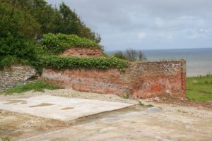 The remains of Primrose Barn in 2026
Sadly there will be no more traditional Norfolk cottages built using locally sourced and hand made materials. The local tradesmen have all gone along with their knowledge and skills, and that is the history within a wall.